

Geographic Data Link, LLC (Technology Company)
best clone rolex watches
| Rensselaer Technology Park 120 DeFreest Drive Troy, New York 12180 United States | Phone: 518-283-4435 Fax: 518-283-0830 E-mail: [email protected] http://www.geodatalink.com |
Organization OverviewPrimary Technologies
- Information Technology
- Application
Secondary Technologies
- Software
Workforce
- 2 to 5 Employees Worldwide
- 2 to 5 Employees in the Capital Region
- 1 Technologist in the Capital Region
NAICS Codes
- 541370
- 541511
- 541611
SIC Codes
- 7389
- 8713
Organization Description
Geographic Data Link, LLC (GDL) is a full service Geographic Information System (GIS) consulting firm that specializes in the understanding and implementation of GIS technology for use in enterprise computing environments.
Unique Technologies Specialization
GDL’s staff alliances with major software companies and detailed industry knowledge allows us to provide high quality, value-priced mapping and geographic information system services. The staff at GDL is highly skilled not only with specific GIS software packages but also with multiple operating systems, networking environments and office productivity software.
GDL provides applications, solutions, training and support specific to their needs.
Products and Services
Parcel Partner
Parcel Partner is a mapping and relational database program,“links” the tax map parcels with the corresponding real property system data. This consolidates the tax maps and land records into one organized, secure electronic filing system.Parcel Partner combines GIS and database technology into a user-friendly Windows application and is available as a web based application and/or client/server.
MAP IT
Map-enables your membership database. Displaying locations of your members on a map will direct visitors to your locations, by category, either individually or by showing all points. Geocoding the physical address of each member establishes geographic coordinates for each one and allows the location to be displayed on a map thus providing a physical location at street level.
CAT (Campaign Analysis Tool)
CAT offers advantages for political campaigning by improving demographic analytical abilities, mapping traditional voter profile data and election district boundaries and “geocoding” voter registration databases that assigns real world coordinates to each voter. GIS is used by the political sector for campaign management because of these functions and additionally.
Research and Development
Patents
Patents issued within the last year: 0
Sales
Sales Channel Utilization
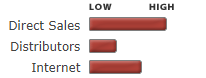
Sales by Market